An LPV approach can feel remarkably similar to an ILS from the cockpit.
The lateral guidance behaves predictably. The glidepath is stable. Vertical guidance is smooth and precise. In day-to-day operation, it is easy to think of an LPV approach as simply “an ILS generated by GPS.”
That mental model is understandable.
It is also incomplete.
An ILS is fundamentally a local system. The aircraft receives two dedicated radio signals transmitted from equipment physically installed near the runway: the localizer for lateral guidance and the glideslope for vertical guidance. (See our page on ILS for details: How does ILS work? ) If those signals are operating within specification, the approach remains available. The geometry is fixed and relatively simple.
WAAS-based LPV approaches work very differently.
There is no glideslope antenna near the runway. In fact, there is no local approach transmitter at all. The entire approach exists as a computed navigation solution generated inside the avionics system using satellite measurements, augmentation data, and integrity monitoring logic.
This distinction matters because it changes the entire failure model.
For background on how GPS interference and signal degradation affect modern avionics systems, see Part 1 of this series: “When GPS Lies (or Disappears): The Hidden Fragility of Satellite Navigation.”
To understand why an LPV approach can suddenly disappear, it helps to first understand what WAAS is actually doing.
At a basic level, WAAS (Wide Area Augmentation System) exists because raw GPS alone is not sufficiently trustworthy for precision-style aircraft guidance. Accuracy is part of the problem, but not the most important part. The larger issue is integrity: the system’s ability to determine whether the position solution can still be trusted.
That difference is subtle but critical.
A GPS receiver may still produce a position that appears stable while the underlying error grows beyond acceptable limits. From the pilot’s perspective, the moving map may look normal. The aircraft may still appear centered on course. Underneath, however, the system may no longer have enough confidence in the solution to legally support vertical guidance.
WAAS exists to monitor that confidence.
Traditional IFR GPS navigation already included integrity concepts through systems such as RAIM (Receiver Autonomous Integrity Monitoring), which evaluated whether enough valid satellite data existed to trust the navigation solution. Pilots flying early non-WAAS GPS approaches often had to verify RAIM availability before departure.
WAAS changed that architecture significantly.
Instead of relying primarily on the receiver’s internal consistency checks, WAAS continuously incorporates external monitoring and correction data from a network of ground reference stations. In practical terms, much of the integrity evaluation that pilots once associated with “RAIM checks” became embedded into the augmentation system itself.
Most pilots noticed the operational simplification. Fewer noticed the underlying shift in how the system determines whether a GPS solution can still be trusted.
Across North America, a network of precisely surveyed ground reference stations continuously monitors GPS satellite performance. Because the exact location of each reference station is known, the system can compare the calculated GPS position against the true position and determine how much error is present in the satellite signals.
Those corrections are transmitted to master stations, processed, and then rebroadcast to aircraft through geostationary satellites. The aircraft’s WAAS receiver uses this information not only to improve positional accuracy, but also to continuously evaluate the integrity of the navigation solution in real time.
This is an important shift in thinking.
WAAS is not simply making GPS “more accurate.” It is continuously answering a deeper question:
“Can this solution still be trusted enough to safely guide an aircraft vertically toward a runway?”
That question becomes increasingly important during an LPV approach.
Unlike an ILS glideslope, which is generated by a physical RF beam near the runway, an LPV glidepath is mathematical. The avionics system computes a three-dimensional descent path using the aircraft’s continuously updated satellite-derived position. As long as the integrity requirements remain satisfied, the system continues providing vertical guidance.
But those requirements are strict.
The receiver continuously evaluates protection limits: calculated bounds representing the maximum likely position error. These limits must remain below defined thresholds for LPV guidance to continue. If satellite geometry changes, correction data is lost, interference increases, or uncertainty grows too large, the protection limits expand.
When they exceed the allowable threshold, the LPV solution is removed.
Importantly, this can happen even when the displayed position still appears reasonable.
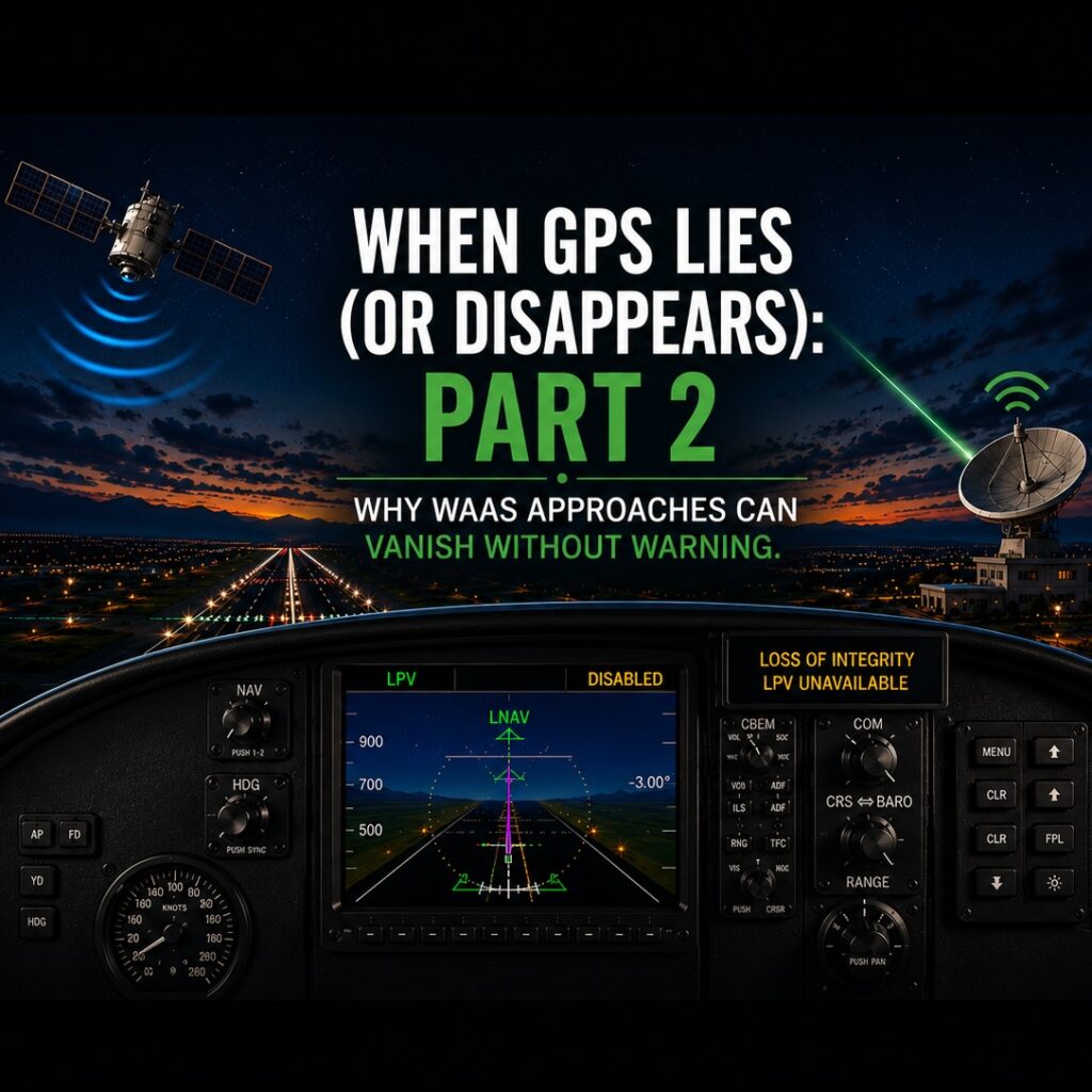
From the cockpit, this can feel abrupt and confusing. The aircraft may have been tracking the glidepath normally moments earlier. Then, suddenly, the approach downgrades from LPV to LNAV/VNAV or LNAV-only, sometimes accompanied by a loss-of-integrity annunciation.
Depending on the avionics suite, the indications can vary slightly. Garmin GNS 430/530 systems may display annunciations such as “INTEG” as LPV capability is removed and the approach reverts to lower minima. Newer GTN 650/750 and Garmin Perspective systems may display messages such as “LPV Unavailable” or “Loss of Integrity” while vertical guidance disappears even though lateral navigation remains active. It’s worth becoming familiar with how your specific avionics suite annunciates and handles these transitions before encountering them in actual IMC.
To the pilot, it can feel as though the system “failed without warning.”
From the system’s perspective, the exact opposite has occurred.
The integrity monitoring logic detected that the confidence margin was no longer sufficient and intentionally removed guidance before the error could become operationally unsafe. In other words, the disappearance of LPV guidance is often evidence that the system is functioning correctly.
This is one of the more important conceptual differences between WAAS and traditional ground-based navigation.
An ILS generally fails because a transmitter or receiver stops functioning properly. WAAS approaches can fail because uncertainty itself becomes too large.
That distinction matters operationally.
Pilots accustomed to treating LPV as equivalent to ILS may not fully anticipate how dynamic satellite-based guidance can be. Satellite geometry changes continuously. RF interference environments evolve continuously. The availability of augmentation data can change from moment to moment. The system is constantly recalculating whether the navigation solution remains trustworthy enough to support precision-style guidance.
Most of the time, this process is invisible.
Occasionally, it is not.
This is why modern IFR flying increasingly requires pilots to think beyond simple equipment availability. The GPS receiver may still be operating. The moving map may still be active. Lateral navigation may still appear normal. Yet the integrity margin required for LPV may already be gone.
The practical implication is straightforward: LPV approaches should always be briefed with the expectation that vertical guidance could be removed at any point prior to minimums.
That does not mean WAAS is unreliable.
In fact, the opposite is true. Modern WAAS systems are extraordinarily capable, and in many cases provide lateral and vertical guidance performance that rivals or exceeds older ground-based infrastructure.
What has changed is the pilot’s relationship with the system.
The avionics are no longer simply displaying navigation information. They are continuously evaluating the trustworthiness of the navigation solution itself and making operational decisions based on that evaluation.
Most of the time, those decisions happen quietly in the background.
Sometimes, they happen at exactly the moment pilots least want them to.